
Schofield Pass in a Hummer
Photos by Ted Waltman & Chuck Kopelson
Updated April 19, 2016
The Schofield pass road located in central Colorado is an old wagon route built in 1883 between Crested Butte and the Crystal / Marble area. Crested Butte is a up and coming trendy ski area. Marble is an old town made famous because the marble used for the Lincoln Memorial and the tomb of the unknown soldier in Arlington National Cemetery was quarried there. Marble is now a sleepy mountain town.
The day before, we wheeled out of Leadville, went over Hagerman pass to Aspen via Basalt. We caught Castle Creek Road out of Aspen, drove to the end and worked our way over Pearl Pass. We camped South of Pearl near the Twin Lakes Trail head. After a good nights sleep and a leisurely breakfast we took a hike on the Twin Lakes trail. We packed up and drove down to Crested Butte. We arrived in town around lunch time and went to the local grocery to replenish our food and water. We drove over to the quaint picturesque main street in Crested Butte, made a couple of sandwiches and started discussing where we'd go next.
It was August 14, 2006. We were very close to the start point of Schofield pass but the writeups were so intimidating we never expected to actually do it. Everything we heard about it raised big red flags as being too dangerous to attempt, especially in a long wheel base wide Hummer. So we decided that it was time to see what this was all about and take a hike.
This is the big deal about doing Schofield Pass !
June 2012 Update - Things have Changed
I received an email from one of my readers who lives in Glenwood Springs on July 3rd, 2012. Here's what he said about the present condition of the road.
Personally, the days of going over Schofield are over unless you have an ATV or on foot and possibly on a mountain bike! Last Saturday I went down to the bridge in my 86 Toyota pickup and turned around. Going to that point there were a couple sections that had small washouts causing me to cross them uphill thus tilting my vehicle hoping the passenger side tires weren't on unstable rock!
The road has not been maintained and the tracks you would drive on are filled with loose rocks more than likely dispersed by ATVs spinning their wheels. The Bridge was covered in loose rocks also.
Ghost towns.com said that
"Schofield pass is known as the most deadly pass in Colorado and for good reason."
Doug Grosjean's Ride to Schofield Pass (August 1980)
"After the river crossing, Schofield Pass is a shelf road hacked out of the side of the mountain. The mountain (and road) is comprised of sharp, layered rock. The road is off-camber, tilting toward the river in many spots, and extremely bumpy. The road is just wide enough for a Jeep, with loose gravel all over the place. As the Crystal River to the right descends rapidly alongside, the road keeps up with the river's descent - I've read since then that it's a 27% grade going into Crystal. For reference, I think the steepest paved road I've ever seen has been around 9%." (Chuck - I don't think so)
"Schofield Pass starts as an easy road as you ride through an open area with a few houses in it, but quickly turns into one the most difficult and dangerous trails in the State of Colorado. On July 9, 1970 nine people died as their car fell into the punch bowl."
WildSnow.com (July 2005) These guys did it on wet snow!
"Nonetheless, it was a wild ride when you didn't know if you'd make it or NOT! The nearest winch anchor is about 300 feet up the hill from here".
" While many of Colorado's 4x4 trails may be technical or near-impossible, few actually make you fear for your life. Bring on Schofield Pass road. Schofield is awesome -- and dangerous.Speak with local officials, and you'll hear words such as "that awful thing should be closed," or "anyone who drives that is stupid," or simply "don't go...you could die."
Fourteen people have died in automobile accidents on the Schofield Pass road -- all from going over the edge in various places on the many miles of shelf road. The accident that's become legend happened in July of 1970. Driven by an inexperienced driver, a five passenger GMC Jimmy went off the Punchbowl Cut, plunged 300 feet, and sunk in 20 feet of water. The vehicle was packed with twelve people -- only three survived (they were either ejected or had left the vehicle before it went over the edge). One of the victims, an eleven year old boy, was taken by the river and never found.
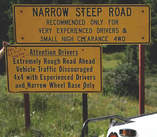
Long wheel-base "full sized" vehicles do not belong on Schofield. The road is too narrow and twisty, with too few turnouts, for anything but nimble Jeeps, quads and the like."
"This route should only be attempted by very skilled and experienced four-wheel drivers, and only in jeep-type, small, high clearance 4WD vehicles. There have been several fatal accidents on this road. Most accidents occur on the descent form Schofield Park to the Devil's Punch bowl."
Wow!, In light of the above we decided to drive up to the road, explore and hike up to the choke point and take some pictures.
We drove NW out of Crested Butte and made a right on the road that leads to Mt. Crested Butte. This is a nice highway that winds up the mountain and ends up in the heart of the ski area where there are condos, hotels and stores. When we were there, there was a ton of new construction. This is going to be a major tourist trap in a year or two.
We continued through the end of town and turned left on a washboard road towards the small hamlet of Gothic. There were lots of sightseers in cars and SUV's on this road.
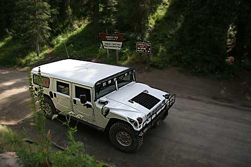
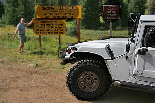
Actually, anybody can 'do' Schofield pass. The actual pass is on an easy car passable road. As we were driving along we were flagged down by a women going the other direction in a Suburban full of people. She told us that the road ended up ahead, there wasn't anywhere to go and that there were all these warning signs. Then she took a second look at what we were driving, laughed and said "it looks like you guys could make it through". A little way further we come to the town site of Schofield. There wasn't anything left to see. We pulled over to take in the 2 big yellow warning signs. One of the signs said that the trail was maintained by the Blue Mesa 4 - Wheelers in Gunnison.
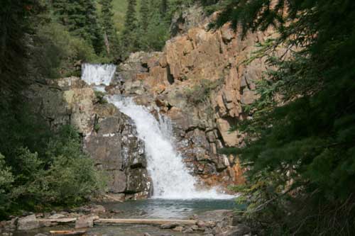
The road turned into a typical 4 wd two track that was an easy drive. We came up to a family on dirt bikes hanging out on a bluff overlooking a river and a waterfall. If we were going to hike the road we had to get the the other side of the river. I didn't feel like getting soaked walking across the river so we scoped out the road on the other side too make sure we could park the Hummer and leave it out of the way of any trail traffic. The road looked pretty wide at the top of the falls so we forded the river behind the falls and parked the truck.
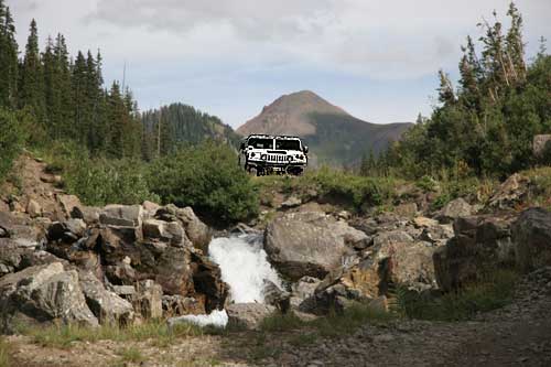
We forded the river in back of the falls.
We Parked the Hummer and went for a hike down the road.

Down the trail looking back at the Hummer
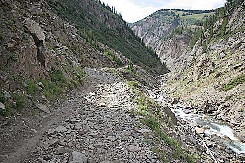
As we hiked, the road really didn't look that bad. It was wide enough with loose stone on the outside edge. The dropoff on the right was down into the river which was littered with broken pieces of trees, but it wasn't a shear drop. Still, not a place I wanted to end up. There were some nice wide areas in case we had to pass  oncomming traffic and the wall on the left wasn't vertical.
A few Quads and dirt bikes came down as we were walking. Ted continued to hike down the trail and I hiked back to bring the Hummer up to our present location. Before I could reach the truck I saw Ted bouncing up the trail on the back of a Jeep. They stopped and I hopped on for a free ride back to the truck. The Jeep driver and his girlfriend said that the road all the way to Crystal was pretty much the same as what we were walking on. Ted and I mulled it over for about 5 seconds and decided to do the infamous Schofield pass road with the Hummer .
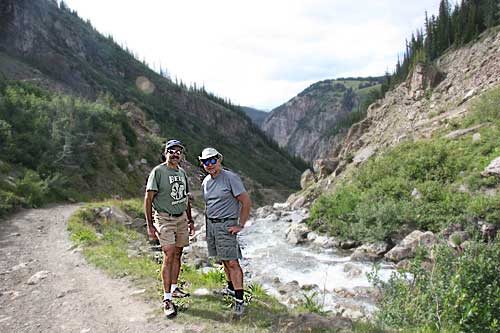
The Jeep guy was nice enough to take our picture before we ventured on.
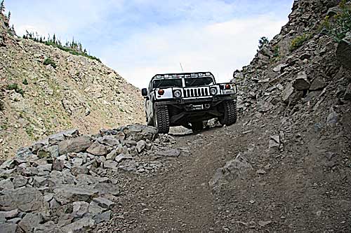
There were a couple of narrow spots where Ted got out and spotted me through.
Most four wheelers are really freaked out when they see a Hummer coming at them head on on the trail. I think the truck visually looks much wider then it really is because it's not that tall. They don't realize that a Hummer can easily put it's two tires up the side of a wall leaving plenty of space for another vehicle to pass. We did discover that there definitly were places on this road where you could not pass. Luckily, we didn't meet any traffic coming the other way.
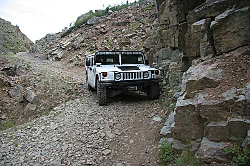
There was this big boulder in the middle of the road. Luckily there was plenty of room for me to easily drive around it and avoid the loose rock on the outside of the road. When you own a Hummer you have to tread even more lightly because you become a target to some off roaders that think the large Hummer vehicle will lay waste to a trail. The fact of the matter is that the Hummer's footprint is very big when you run the 12.5" wide tires at low pressure. That's why an 8000 pound truck can float on sand. When you drive the Hummer you crawl over the terrain and walk down rock piles. The truck has enough torque so it isn't necessary to rev up the engine and drop the clutch like you sometimes do in a CJ. I didn't want to be responcible for caving rocks off the road down into the ravine. I can only imagine the hard work it takes to keep this road maintained.
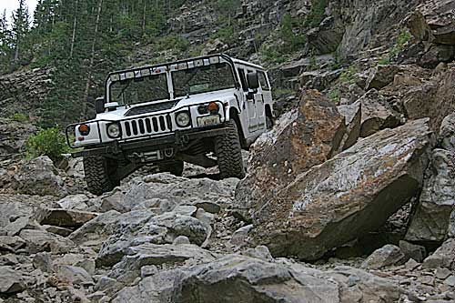
The Hummer just walks down this kind of stuff. It's almost too easy.
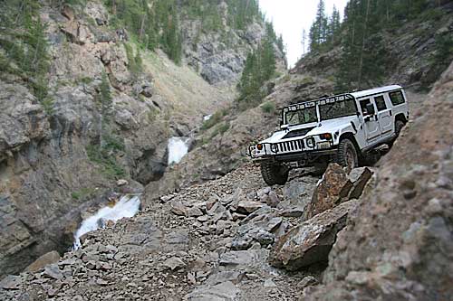
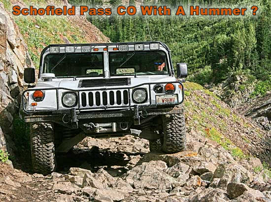
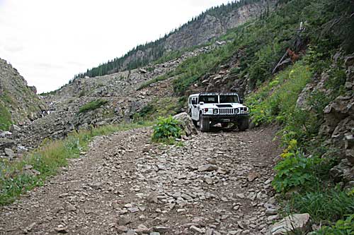
This is the roughest part of the trail. This whole area in the canyon is known as the 'Devils Punchbowl'. I'm guessing that I'm at the 'Punchbowl Cut' which is the shelf road above the waterfall. The actual Punchbowl is the area by the waterfall and the plunge pool below.
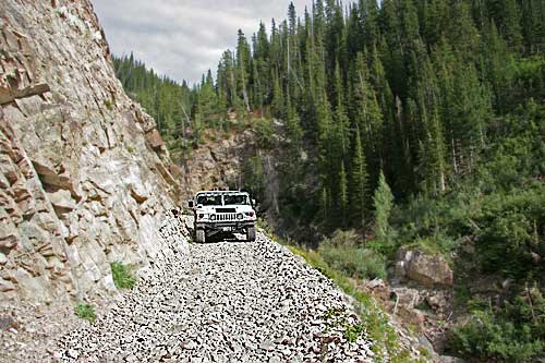
This is the second shelf road. It wasn't as rocky as the first but the edge was much higher up and there was a lot more loose stone. This was the section where passing was pretty much out of the question. Since we were coming over as the sun was going down I was completely blinded a couple of times. I was playing it safe and staying close to the wall when I ran the truck solidly into a rock on the right side. Luckily I have this custom hunk of steel bumper. The truck just bounced off the rock with no damage. I did catch a pile of shit from Ted for this one.
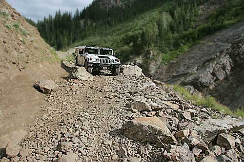
A little farther down the trail you will see a bridge below. I've since been told that the two small streams where most people have died are beyond the bridge just after you re-enter the trees after the steep hill covered with loose rocks between the bridge and the Crystal Mill. If you look down below there is supposed to be the remains of a vehicle.
I don't remember anything remarkable about this section of the road. In my mind I was home free with a nice wide road! We didn't even take pictures! All I remotely remember is possibly some wet spots on the road. I'll have to return next year and be more observant.
The Schofield pass road is a beautiful scenic trail through spectacular mountain country. Frankly, neither of us could see what all the fuss was about. I basically just drove down the road with a few tight spots. There were no instances that required any technical maneuvering. After talking with Lou Dawson a veteran of Schofield Pass I realized that we had an easy time for the following reasons.
- Weather and road conditions were very good. This is the main factor. Once things get wet or there is snow and ice all bets are off even on the easiest roads. A beautiful summer day can turn into a harrowing experience if the weather changes. Evidently one of the multiple deaths was caused by hidden ice in one of the stream crossings during hunting season.
- The Blue Mesa 4 - Wheelers have improved the road.
- We both have over 25 years of experience driving off road.
- The Hummer really is an exceptional off road vehicle especially with a rear Detroit locker.
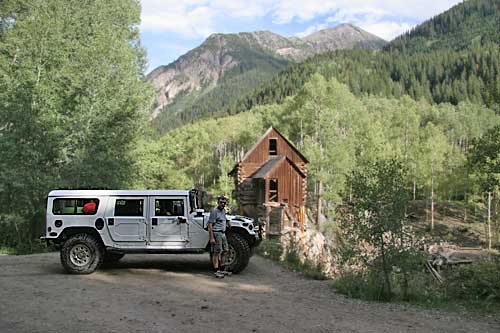
This is the 'Old Mill at Crystal', which is reputed to be the most photographed site in Colorado.
One of my readers sent me this email on 7/23/2009. This morning a motorcycle fan friend shared with me a recent Colorado adventure, a 25 pass trip (all on paved roads) woven through the state. It reminded me of Schofield Pass, so I did a Google search and I found your site.
In the summer of 1964, my wife and I (just 2 years married) were camped at the Gothic Picnic Ground USFS campground north of Crested Butte. We'd driven west from St Louis in our 1958 VW Bug for a few weeks of R&R. One day we decided to drive up and have a look at Schofield Pass just a little north of the campground. There were some nasty, deep, muddy stretches in the meadow area just before the pass, but we managed not to get stuck. Near the junction with the Crystal River Canyon, we encountered someone driving a big GM sedan. He allowed that it could be navigated in something less than a Jeep. He'd done it himself. We didn't want to take a chance at getting trapped in mud and we'd always wanted to see Marble so we headed over and down. My recollection is that of a long, steep stretch on the left side of the river with a crossing at the bottom (which seemed like the end when seen from the top) and then another nasty long stretch on the right hand side of the river before we reached paved roads at the bottom. It was 10 PM when we finally reached our campsite having taken the shortest paved return route back. We traded in the Bug the next year for a 21 window van. We never tried anything quite like Schofield Pass in that vehicle. It is (was) negotiable in 1964 in a humble Bug, however.
